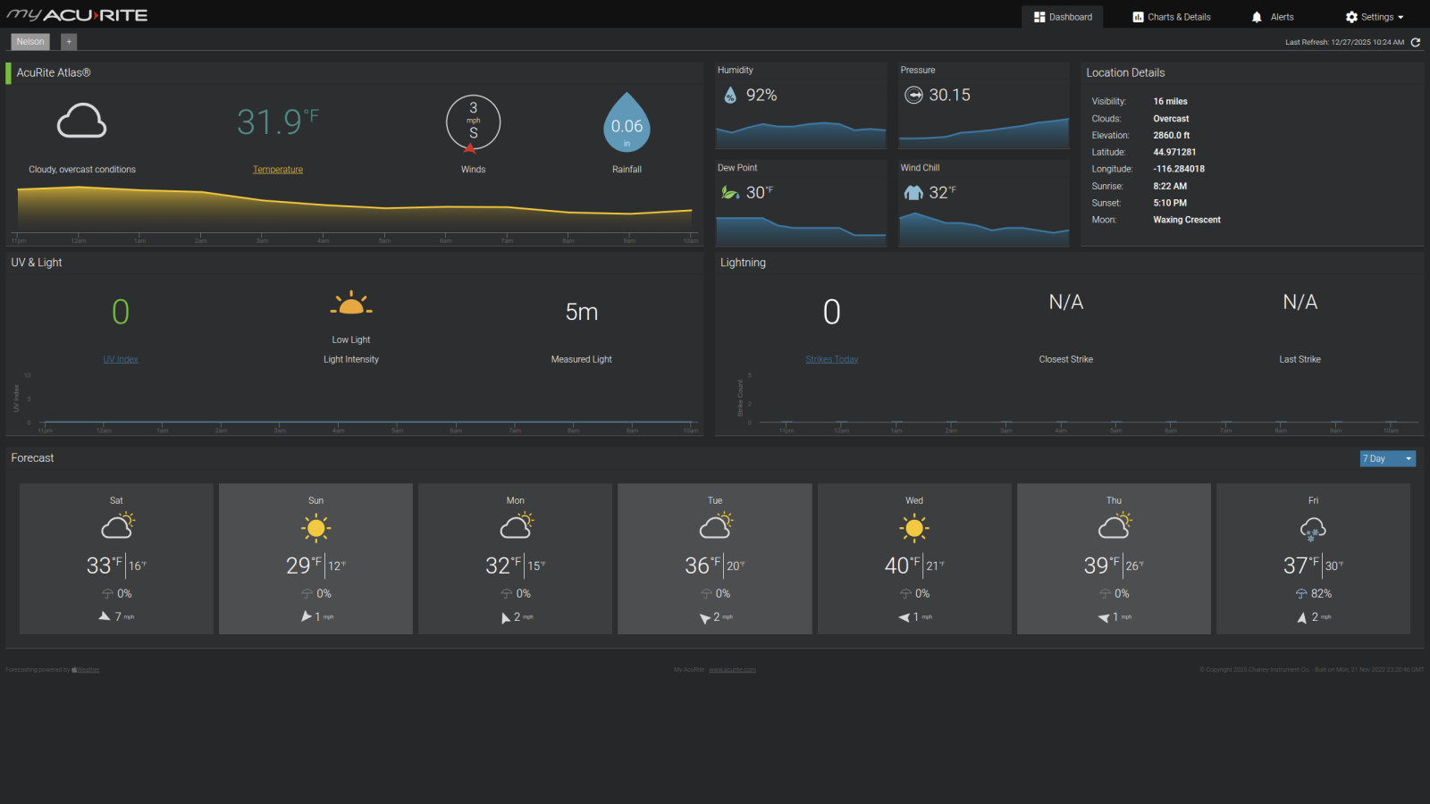
This last summer, after the landslide, I lost my weather station. Just up and died one day. I replaced my older weather head with all modern equipment. I purchased an Acurite Atlas weather station. It includes WiFi ability to allow the data to be sent to the app on my cellphone. I was looking for a way to share this data soon, which I'm going to publish on Weather Underground, so my local friends and locals can see up the canyon from Riggins or down the canyon from New Meadows.
I'm also looking into the Linux version of the software for data capture of weather data. There are a few software out there that can read the data stream from the weather head directly.
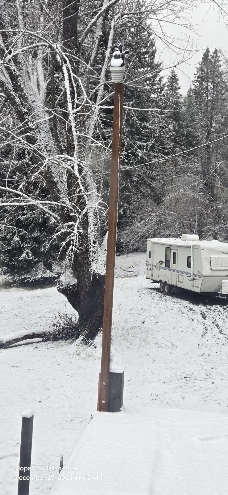
Currently, how the weather head is mounted and set up. I'm about 2 to 3 feet above the ridge of the roof. Better wind data now. The head is solar powered and USB Type-C rechargeable if needed.
I want to be able to study past weather trends to verify the actual Global Warming or Climate change BS. The other problem we have is that the closest radar from the south is Boise, ID, and then the closest radar from the north is Lewiston, ID. When you visit any other weather site like NOAA.gov or any weather apps, the weather data is calculated for us here at an elevation of 2860 feet above sea level. Even looking at the MyRadar app on Android, there is a blank spot over us where we are actively watching it rain here hard, and there is NOTHING on any radar showing this storm. Like right now, we are looking at nighttime temperatures down to +17℉. It was really a pain to plan trips and travel for food and supplies, not understand the current weather in this dead zone from New Meadows to Grangeville roughly.


This last summer, after the landslide, I lost my weather station. Just up and died one day. I replaced my older weather head with all modern equipment. I purchased an Acurite Atlas weather station. It includes WiFi ability to allow the data to be sent to the app on my cellphone. I was looking for a way to share this data soon, which I'm going to publish on Weather Underground, so my local friends and locals can see up the canyon from Riggins or down the canyon from New Meadows.
I'm also looking into the Linux version of the software for data capture of weather data. There are a few software out there that can read the data stream from the weather head directly.
Currently, how the weather head is mounted and set up. I'm about 2 to 3 feet above the ridge of the roof. Better wind data now. The head is solar powered and USB Type-C rechargeable if needed.
I want to be able to study past weather trends to verify the actual Global Warming or Climate change BS. The other problem we have is that the closest radar from the south is Boise, ID, and then the closest radar from the north is Lewiston, ID. When you visit any other weather site like NOAA.gov or any weather apps, the weather data is calculated for us here at an elevation of 2860 feet above sea level. Even looking at the MyRadar app on Android, there is a blank spot over us where we are actively watching it rain here hard, and there is NOTHING on any radar showing this storm. Like right now, we are looking at nighttime temperatures down to +17℉. It was really a pain to plan trips and travel for food and supplies, not understand the current weather in this dead zone from New Meadows to Grangeville roughly.
Edited by Mopar1973Man