February 22, 20196 yr Owner Hell yeah! Good for him... Now that's using your noodle and going after the work!
February 22, 20196 yr Staff 50 minutes ago, NIsaacs said: Is that for real, about $900 per hour? Remember, the populous of Seattle believe in 'Global Warming' and will pay any thing to get rid of the white stuff.
February 22, 20196 yr Author The article says that he charges $125/hr for plowing in Idaho. In Seattle he was charging between $500-$750/hr for it.
February 22, 20196 yr 16 minutes ago, Manimalmother said: The article says that he charges $125/hr for plowing in Idaho. In Seattle he was charging between $500-$750/hr for it. Yup, he needs to go to church, lol
February 23, 20196 yr Owner Now he better come home. https://forecast.weather.gov/showsigwx.php?warnzone=IDZ011&warncounty=IDC003&firewxzone=IDZ401&local_place1=12 Miles S Riggins ID&product1=Winter+Storm+Warning&lat=45.2453&lon=-116.3321#.XHFDknVKgzA URGENT - WINTER WEATHER MESSAGE National Weather Service Boise ID 532 AM MST Sat Feb 23 2019 ...A PACIFIC STORM WILL BRING HEAVY SNOW THIS WEEKEND INTO NEXT WEEK... .A storm system is moving into the Pacific Northwest today, and will last into early next week. This will bring a prolonged period of moderate to heavy snowfall to the central Idaho mountains, and light to moderate snow to Baker County and the Upper Weiser River Basin. Snow has already begun in the mountains as of 5 am this morning. Starting this afternoon, gusty winds will accompany the snowfall resulting in blowing and drifting snow in some areas. Light snow accumulations are possible in the Snake Plain this morning through Sunday morning, with a changeover to rain Sunday afternoon. Sheltered low-elevation valleys in Baker county and the Weiser River basin could hold onto snow into Monday. IDZ011-013-028-232215- /O.CON.KBOI.WS.W.0004.000000T0000Z-190227T0000Z/ West Central Mountains-Boise Mountains-Camas Prairie- 532 AM MST Sat Feb 23 2019 ...WINTER STORM WARNING REMAINS IN EFFECT UNTIL 5 PM MST TUESDAY... * WHAT...Heavy snow and blowing snow. Travel will be very difficult to impossible at times. Total snow accumulations of 18 inches to 3 feet, with localized amounts up to 5 feet in the highest west-facing elevations, are expected. Gusty winds will develop starting this afternoon and last through Tuesday, resulting in blowing and drifting snow. * WHERE...West Central Mountains, Boise Mountains and Camas Prairie zones. * WHEN...Until 5 PM MST Tuesday. * ADDITIONAL DETAILS...Winds gusting as high as 35 mph will cause areas of blowing and drifting snow. PRECAUTIONARY/PREPAREDNESS ACTIONS... A Winter Storm Warning for snow and blowing snow means severe winter weather conditions are occurring. If you must travel, keep an extra flashlight, food and water in your vehicle in case of an emergency. The latest road conditions can be obtained by calling 5 1 1. Then the forecast here... https://forecast.weather.gov/MapClick.php?lat=45.24525270653619&lon=-116.3321042060852&site=mso&unit=0&lg=en&FcstType=text#.XHFDrXVKgzB
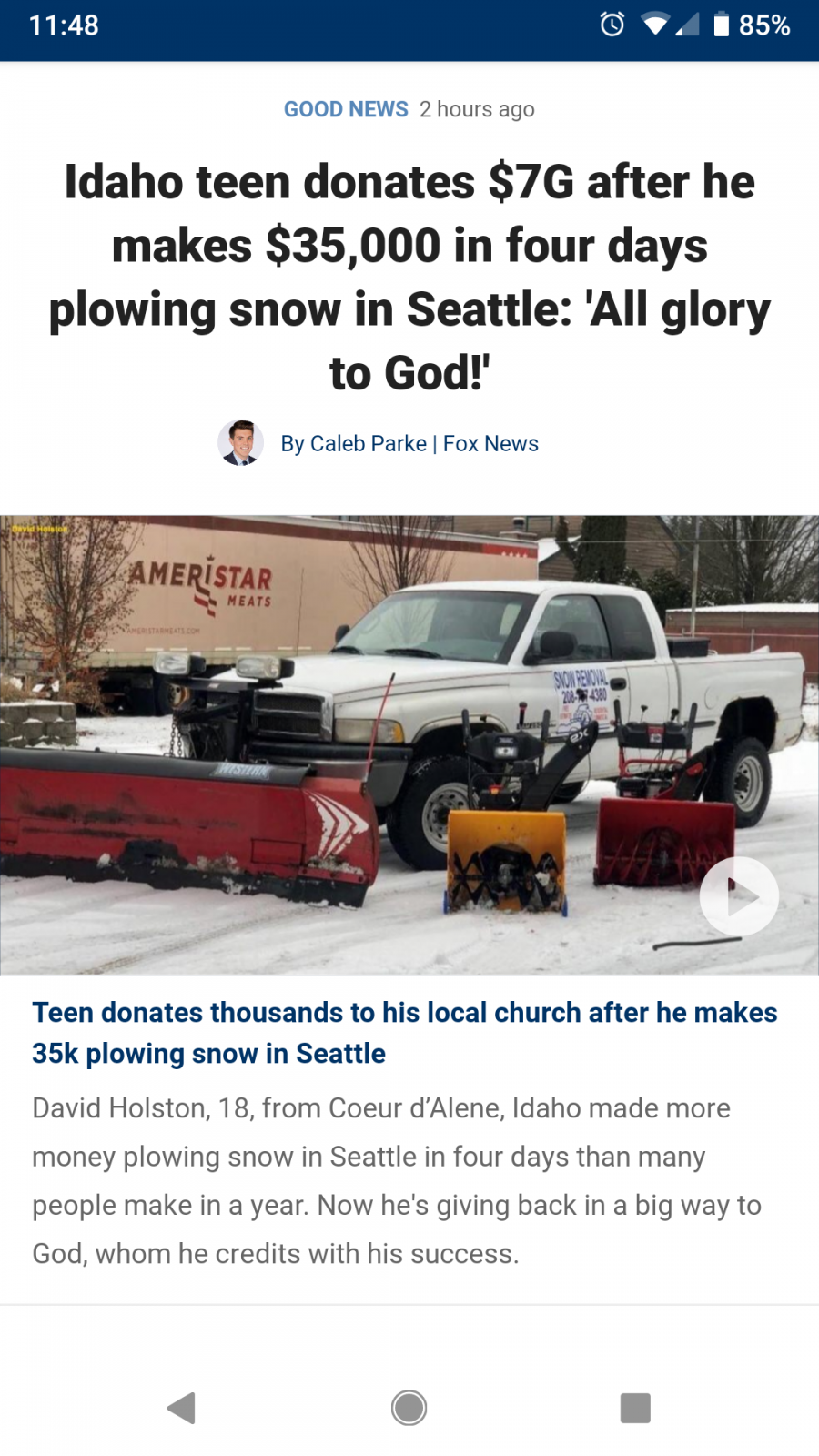
Anyone else see this? Thought it was neat.